Initial setting and problem
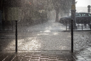
Pollution from rainwater is considered to be the most important problem to be solved in urbanized areas. Most European cities have already arranged their wastewater management and thus, the rivers are much less nutrient-rich. According to the data from the State Environmental Monitoring, in 2010 over 300,000 tones of nitrogen flowed into the Baltic Sea from Polish rivers, in 2018 less than 150 thousand tones. So, the effect of implementation of the National Program for Urban Waste Water Treatment is very clear. However, the largest part of pollution still comes from agriculture and from Atmospheric deposition. Harmful substances get into receivers through overflows from the combined sewage system. Moreover, there are many scattered, uncontrolled rainwater drainage systems in urbanized surfaces – streets, parking lots, pavements, etc. Rainwater from urban surfaces is a source of biogenic compounds, but also of many other pollutants, such as: petroleum substances, heavy metals or microplastic. HELCOM draws attention to the fact that the load carried by rainwater should be included in diffuse sources, as these types of sources do not often have a separate outlet. In cities, there is a lack of rainwater sewage systems integrated with treatment systems where necessary. In addition, combined sewers cannot be separated in most places. The most difficult situation prevails in small cities, which find it difficult to coordinate activities and planning.
Purpose of the NOAH project
Appropriate management of urban stormwater systems and proper spatial planning are essential for environmental protection in urban areas. The increased load of pollutants, nutrients and hazardous substances discharged into rainwater and combined sewers may adversely affect the quality of inland and marine waters. The climate crisis, which causes more frequent extreme weather events, such as heavy rainfall preceded by droughts resulting in floods and constantly rising sea levels, magnifies the problem. Moreover, rainwater and snowmelt management is a problem that generates significant costs and requires an appropriate division of responsibilities between operators, infrastructure owners, public administration and local government. That is why in every region a responsible entity is required to coordinate all work, to have control over the entire system. In addition, it is necessary to develop a joint action plan and encourage all stakeholders to organize the rainwater management. Only proper cooperation, effectiveness of decisions and the right tools are the road to success. Therefore, the NOAH project is a great opportunity for Baltic cities to find a fairly universal tool for managing combined sewerage.
The purpose of the NOAH project is to help Baltic cities become familiar with these issues and to develop tools for improving spatial planning as well as the operation of the existing urban drainage systems. Joint implementation of innovative solutions in order to avoid the deterioration of the Baltic water quality caused by the runoff of untreated rainwater and sewage from combined sewage system is the main goal of the project. The reconstruction and separation of all combined sewer systems in the cities of the Baltic Sea catchment area is obviously unrealistic, so NOAH uses both passive and active methods such as holistic urban planning, real-time control of urban drainage systems and awareness-building of stakeholders. Real-time control is used to retain excessive rainwater flow in the network, thus avoiding discharges from storm overflow.
NOAH combines computer modeling of drainage systems with traditional urban planning techniques. It indicates the need to move from fragmented planning based on selected small parts of cities to a method based on the entire urban catchment area. The cities participating in the project have a common problem of using a piecemeal approach to planning, which is usually not effective.
Measurements of the quality of rainwater and waste water are also used for modeling. The volume of the effective runoff is directly related to the amount and quality of pollutants that rainwater rinses from the surface. This polluted storm water flows directly into rivers and into the sea, or is collected by separated or combined sewer systems. Proper spatial planning can reduce runoff and thus reduce the discharge of hazardous substances into the Baltic Sea.
The aim of the project is therefore to analyze selected areas in a global context and under different climate scenarios, taking into account the amount of runoff in downstream, close to estuary, where this runoff is one of the factors determining the pollution load. Models and analyses will lead to the development of effective methods for reducing discharges from overflows of combined sewerage. These methods are designed to be easily replicable in other cities around the Baltic Sea.
Project partners
The project consortium consists of 18 partners from six Baltic countries. Tallinn University of Technology is the leader of the project. Other partners and observers are six cities of different sizes, three water companies, four organizations and seven universities and research institutes. Poland is represented by the Gdańsk University of Technology, Słupsk water utility and the Polish Waterworks Chamber of Commerce. The list of project partners is presented in the table below. Associated organizations are the Union of the Baltic Cities, the Estonian Ministry of Environment, the Satakunta Chamber of Commerce.
| Partner | Sector | Country |
| Tallinn University of Technology – leader | education, research and development | Estonia |
| Satakunta University of Applied Sciences | education, research and development | Finland |
| Gdansk University of Technology | education, research and development | Poland |
| City of Haapsalu | public body | Estonia |
| City of Rakvere | public body | Estonia |
| Municipal enterprise of Liepaja | public body | Latvia |
| Finnish National Institute of Natural Resources LUKE | education, research and development | Latvia |
| Estonian Organization of Water and Sewerage EVEL | industry organisation | Estonia |
| City of Pori | public body | Finland |
| University of Halmstad | education, research and development | Sweden |
| Chamber of Commerce of Polish Water Works | industry organisation | Poland |
| Riga University of Technology | education, research and development | Latvia |
| Municipality of Ogre | public body | Latvia |
| Słupsk Water Works | public body | Poland |
| Technical University of Denmark | education, research and development | Denmark |
| Enterprise Jurmalas udens | small and medium-sized enterprises | Latvia |
| Municipality of Söderhamn | public body | Sweden |
| Rakvere Water Company | small and medium-sized enterprises | Estonia |
The cities participating the NOAH project already have knowledge and experience related to extreme weather events, river-side hazards, river-sea interactions and ice jams. All cities and water companies have their own long-term experience in the field, but do not often have the resources to implement innovative solutions that effectively reduce risks. Thanks to international cooperation, universal tools are created and can be used in many cities.
Modeling
Modeling is an important part of the project. The goal is to gain knowledge about the current and projected sewage flows and the risks associated with network overflow. The stages of construction of the models include:
- Selection of an appropriate pilot area;
- Collection of network data from different sources such as maps, GIS, land use data, fieldmeasurement results, design drawings, altitude data, street and building layout,watercourses, groundwater, databases, etc.
- Decision on an achievable level of fidelity of the model;
- Execution of the initial model for testing;
- Filling gaps in data (based on statistical methods, literature and interpolation orextrapolation of available data);
- Checking the accuracy of data and reducing uncertainty with a support of local specialists;
- Field measurements for calibration and validation of the model.
Modeling is based on the Storm Water Management Model (SWMM) developed by the United States Environmental Protection Agency (EPA). SWMM was designed to support local, state and national rainwater management entities to reduce runoff through infiltration and retention, as well as to help reduce discharges polluting water receivers. The model is quite universal, easy to use and free of charge, that is why it is used more and more widely around the world. It is used for planning, analyzing and designing systems related to rainwater, sewers, sanitation and other drainage networks. SWMM allows users to track the quantity and quality of outflow generated in each catchment area as well as the flow rate, channel filling level and water quality in the sewer network. In addition, it gives a possibility to take into account different hydrological processes that affect urban areas, like time-changing rainfall, evaporation, snow fall and melting, retention in hollows, infiltration of rainfall into the soil, percolation of infiltrated water into groundwater layers, flows between groundwater and drainage systems, capture and retention of contaminants. Spatial variability in all these processes is achieved by dividing the test area into a set of smaller catchment areas. SWMM also includes a flexible set of hydraulic modeling functions used to control outflow and monitor water quality.
Real Time Control – RTC
Work on a real-time run-off control tool is designed to minimize the effects of increased water flow in the sewer network during rainfall. The considered effects include both the amount of water (flooding) and its quality (negative impact on receivers). Sewer control has two dimensions in the project. The first one is the use of project-developed software (RTC Tools) to optimize sewerage work in pilot areas. Optimization involves iterative mathematical models running while virtual flow regulation through elements of hydrotechnical infrastructure (e.g. tanks, flow regulators). As a result of the analyses we will receive a proposal of an optimal scenario for controlling the sewer system and to obtain the smallest possible volume of overflow from the sewer system. These results will allow the optimal use of existing hydrotechnical infrastructure, but also will provide new solutions that will be tested in a virtual way.
The second dimension of this task is a system presenting the state of operation of the sewer system, based on current monitoring results, meteorological forecasts and mathematical modeling. Using these data sources the system should provide information on the current and projected sewer filling level, overflows, wastewater quality.
Extreme Weather Layer – EWL
The EWL model is a combination of modeling and GIS spatial planning of municipalities. It combines results of a hydraulic model with cadastral maps to visualize the location of places at risk of flooding. These locations should be the subject of particular attention in future planning. Various climate scenarios have been included in the EWL to analyze the effectiveness of measures such as retention tanks and green-blue infrastructure.
It was difficult to adopt a single climate change scenario for all the cities participating in the project. Experts will rely on scenarios based on so-called representative concentration pathways (RCP) scenarios. The RCP database presents forecasts of emissions, pollution concentrations and changes in land cover. It is based on projected changes in greenhouse gas concentrations, for which changes in meteorological parameters were subsequently calculated. Three scenarios were selected for the NOAH project: RCP4.5 and RCP8.5 and the third one based on local history of measurement extremes. Each scenario assumes an increase in temperature and warming varying from region to region, the highest occurring in the north. The project partners assumed that the EWL will be based on the extent of water flowing from manholes into streets during overflows of the sewers.
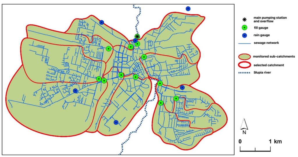
Słupsk as one of the pilot cities
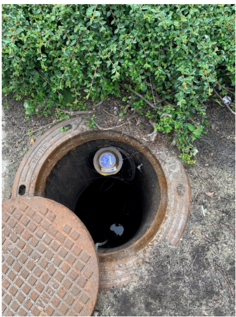
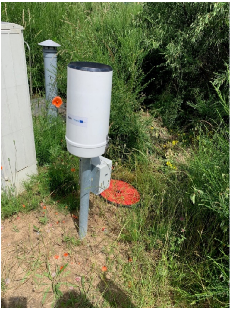
A catchment area of 22 km2 was selected for modeling in Slupsk, Poland. There is a part of combined network with overflow located near main sewer collector leading to the waste water treatment plant (Image 1). For the purposes of the project analyzes, the catchment area has been divided into 12 sub-catchments, each of which is equipped with a channel filling gauge. In addition, six rain gauges were installed.
Gdańsk University of Technology has started to create the model for selected catchment in Slupsk. The model uses different groups of data, divided into four types (as in the table below).
| Results of monitoring provided by Słupsk Water Utility and Gdańsk University of Technology: | Spatial data: |
| – channel fill level – concentrations of contaminants – pump efficiency – precipitation – water demand – water level in Słupia river | – network data (length, elevation, depth, material, diameter and section shape) – location of wells, tanks and pumping stations – landform – land use – map of streets and buildings |
| Forecast data: | Results of external monitoring: |
| – precipitation | – flow in Słupia river and its condition – precipitation – water quality in the receiver |
The model is based on more than five thousand sections of sewers and wells. The area for which surface run-off is calculated is divided into 280 sub-catchment areas. They are described by their shape, slope, roughness of the substrate and the share of impermeable surfaces. In addition to surface run-off and stormwater infiltration, it was also necessary to take into account the inflow of sanitary sewage. This inflow was calculated on the basis of hourly and seasonal profiles based on 10-minute data on water demand and waste water outflow during rain-free periods. Suspended solids and chemical oxygen demand were selected in modeling as the quality parameters of the wastewater. These parameters were selected based on the availability of data for the model calibration and validation. Modelling results are data on the flow rate and level of wastewater in the sewer system, as well as the quality of wastewater in
several parts of the network. The model is still under calibration and the results of calculations are planned for the end of 2020.
Meeting of the Polish NOAH team in Słupsk
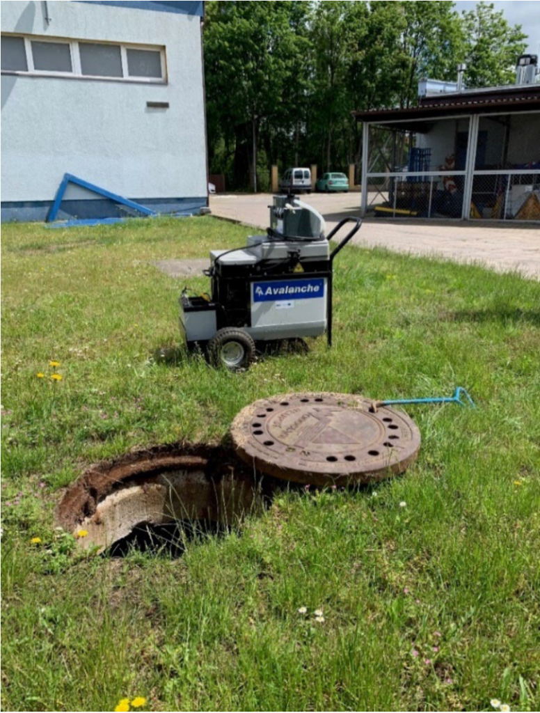
All NOAH partners were supposed to meet in Gdansk in April 2020. Unfortunately, the Sars- Cov-2 situation canceled the plans, and we hope to be able to welcome Baltic friends in the near future. In the meanwhile, the Polish project team met in Słupsk in June to get acquainted with the state of the works. Słupsk Water Utility hosted partners from Gdańsk University of Technology and the Economic Chamber Polish Waterworks. The meeting was an opportunity to see the selected infrastructure as well as equipment purchased under the project. We also conducted another campaign of sewage collection for testing.
Wastewater quality tests include basic parameters such as pH and electrical conductivity (ion measurement in the sample). A total suspension solids (TSS), both organic and mineral, is considered as a key parameter which can be a sign of a very dangerous water pollution such as heavy metals. Size of the suspended solids was obtained thanks to laser granulometer (Malven Instruments Ltd 2000). This data can be used to select appropriate waste water treatment method. Measurements of total and dissolved organic carbon are also performed. Studies of the content of biogenic compounds (nitrogen, phosphorus) which are responsible for eutrophication are also important. Their negative impact varies depending on the Baltic Sea area.
Nitrogen is considered to be a biological balance-limiting substance in the Baltic Sea. In coastal areas, south of the Bothnian Bay, the amount of nitrogen and phosphorus are exceeded, while phosphorus causes disturbances in inland waters. Heavy metals, metals and semi-metals are mainly found in storm water runoffs. This group of contaminants includes cadmium, copper, nickel, lead and zinc. Due to street run-off, petroleum compounds are measured mainly as polycyclic aromatic hydrocarbons (Acenaphthene, Anthracene, Benzo(a)anthracene, Chrysene, Fluoroanthene, Fluorene, Naphthalene, Phenanthrene, Pyrene, Benzo(a)pyrene, Benzo(b)fluoroanthene, Benzo(g,h,i)perylene, Dibenzo(a,h)anthracene, Benzo(k)fluoroanthene, Indeno(1,2,3-cd)pyrene, Acenaphthylene).
Another important group of pollutants monitored is microbial contaminants, mainly of faecal origin.
In addition, the samples will be marked with the so-called new generation contaminants: microplastics (dimensions <0.5 mm), phthalates (Benzyl butyl phthalate, Bis(2-chloroethoxy) methane, Bis(2-chloroethyl) ether, Bis(2-ethylhexyl) phthalate, 4-Bromodiphenyl ether, 4- Chlorodiphenyl ether, Bis-(2- chloroisopropyl) ether, Dibutyl phthalate, Diethyl phthalate, Dimethyl phthalate, Di- n-octyl phthalate). Testing of the content of selected pesticides is also carried out (α-BHC, β-BHC, ɤ-BHC, δ-BHC, Heptachlor, Aldrin, Heptachlorepoxide Isomer B, ɤ- Chlordane, α-Chlordane, Endosulfan I, 4,4‘- DDE, Dieldrin, Endrin, Endosulfan II, 4,4‘- DDD, Endrin aldehyde, Endosulfan sulfate, 4,4‘-DDT, Endrin Ketone, Methoxychlor).
The meeting in Słupsk was an excellent opportunity to get acquainted with the investments in infrastructure and the work on modeling. We hope that the experience of this city will allow to spread good practices in other Polish cities. The problem of storm water overflows from combined sewers is becoming increasingly challenging due to climate change and rainfall characteristics.
Authors
Jolanta Fracka, Słupsk Water Utility
Remigiusz Łyszyk, Słupsk Water Utility
Klara Ramm, Chamber of Commerce Polish Waterworks Magdalena Gajewska, Gdansk University of Technology Katarzyna Kołecka, Gdańsk University of Technology Rafał Ulańczyk, Gdańsk University of Technology
Piotr Zima, Gdańsk University of Technology
NOAH – Protecting Baltic Sea from untreated wastewater spillages during flood events in urban areas is financed by the European Regional Development Fund under the INTERREG Baltic Sea Region Program 2014-2020, from 01/01/2019 to 31/12/2021.